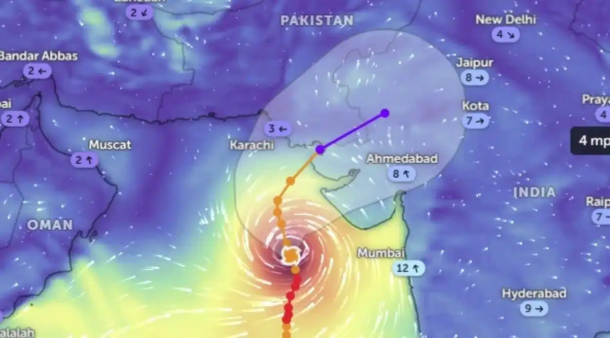
Southern coastal regions of Pakistan remained on high alert on Sunday after the Pakistan Meteorological Department (PMD) issued warnings about a severe cyclonic storm approaching Karachi and other parts of Sindh from the Arabian Sea.
In a detailed statement, PMD reported, “The Extremely Severe Cyclonic Storm (ESCS) ‘Biparjoy’ over the east-central Arabian Sea has moved further northward during the last 12 hours and now lies near Latitude 18.7°N & Longitude 67.8°E at a distance of about 690km south of Karachi, 670km south of Thatta and 720km southeast of Ormara.”
The department added that favorable environmental conditions, such as sea surface temperatures of 30-32°C, low vertical wind shear, and upper-level divergence, support the system’s maintenance of its severity.
Extreme Weather Conditions Expected
The cyclonic storm produces maximum sustained surface winds of 180-200 Km/hour with gusts reaching 220 Km/hour around the system center. The PMD also noted phenomenal sea conditions around the system center, with maximum wave heights of 35-40 feet.
According to the PMD’s predictions, ‘Biparjoy’ will likely track further northward until June 14 morning. It is expected to re-curve northeastward and cross between Keti Bandar (Southeast Sindh) and the Indian Gujarat coast on June 15 afternoon as a Very Severe Cyclonic Storm (VSCS).
Preparation and Potential Impact
In response to the approaching cyclone, the PMD’s cyclone warning center in Karachi continuously monitors the system and will issue updates accordingly.
Potential impacts of the cyclone could include widespread wind-dust/thunderstorm rain with some very heavy/extremely heavy falls, accompanied by squally winds of 80-100Km/hour likely in Thatta, Sujawal, Badin, Tharparker and Umerkot districts from June 13 to June 17. Similar conditions are expected in Karachi, Hyderabad, Tando Muhammad Khan, Tando Allayar and Mirpurkhas districts from June 13 to June 16.
PMD warned that high-intensity winds might cause damage to loose and vulnerable structures, and a storm surge of eight to 12 feet is expected at Keti Bandar and surrounding areas — the possible landing point of the storm.
Safety Measures and Guidelines
Fishermen have been advised against venturing into the open sea until the system has passed, which is expected by June 17. The PMD has cited the potential for very rough/high sea conditions and high tides along the coast.
The Karachi Port Trust (KPT) issued safety guidelines in response to the anticipated cyclonic storm, designed to protect ships and port facilities from potential damage during adverse weather conditions.
Radio Pakistan reported that the National Disaster Management Authority (NDMA) had urged people to avoid shorelines and follow local authorities’ instructions in case of any emergency.


